Current Projects
The Bi-County Parkway information is below. For information on other projects, hold your cursor over the "Current Projects" menu bar above and a drop-down menu will appear.
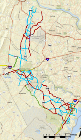
What is now called the Bi-County Parkway has been one part of an overall transportation plan for decades. The map above shows the current proposed route, which is different from older iterations in that the road isn't a bypass of the Washington Beltway, and there's no direct connection to Maryland and points north.
When this road was first proposed, it was one of several different routes studied, both to the east and west of I-95. The reason for the road was to route thru traffic around the Beltway to relieve congestion on that road. The eastern routes (there were several) would have mostly followed the Maryland Rt. 301 corridor, breaking off from I-95 around Petersburg and re-connecting to it above Baltimore. There were also a handful of western routes, some of which connected to I-95 south of Rt. 234, but all of them connected to Maryland I-270.
The road, as currently planned, would follow the path of current Rt. 234 from I-95, pass through the Independent Hill area and on to I-66. It would follow a new path north of I-66, connect to the back side of Dulles Airport and end at Rt. 7. It is planned to become a major six-lane truck route, serving an expanded freight operation at Dulles. It would skirt the edge of the Manassas Battlefield and pass through the Rural Crescent of Prince William County.