Older Projects
Purcell Road Upgrade
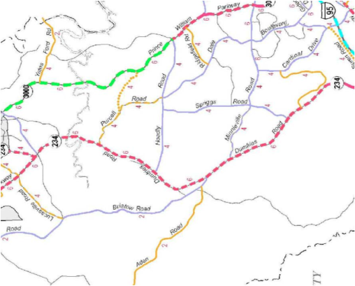
Purcell Road is long-range planned by the county to be a four-lane divided highway that will traverse the area from the current intersection with Rt. 234 across mid-couny to a new connection with the Prince William Parkway. This new connection is planned to follow the path of the current Peaks Mill Drive in the Hunters Ridge community, which was proffered to be designed with a 110 foot wide right-of-way to handle a four lane highway. The road will be extended to connect with the current Purcell on one end and the parkway on the other, and those connections are also proffered. The current Purcell connection to Hoadly Road will remain and will also be widened to a four-lane highway under the plan. There is a 600 acre undeveloped parcel on both sides of Prince William Parkway in the vicinity of the new connection that the new expanded road will provide access for, along with other undeveloped parcels in the corridor. This expanded and extended Purcell Road is not funded and is not planned to be built in the near future, but the concept is important to folks in the area, particularly those whose homes lie in the projected path. We are gathering community opinion on this new road at this time, and on how residents would like their community to look and feel in the future. Above is a map of the proposed route from the county Comprehensive Plan (the dotted yellow line is the new section of Purcell).
Here's the language from the county Comprehensive Plan:
Purcell Road East (Purcell Road to Prince William Parkway) (106’ MC-2 standard) – This proposed mid-County connection between Route 234 and the Prince William Parkway will provide access from planned residential areas north of Hoadly Road. The recommended right-of-way corresponds with the MC-2 standard typical section provided within the County’s DCSM.
Related to the above are improvements to the Purcell Road/Rt. 234 intersection that are currently in the final planning stages. This section is funded and construction is planned for next year. It's unclear at this time if the intersection design was predicated on the planned future four lane highway connection to Prince William Parkway. The county staff report is available here: http://www.pwcgov.org/documents/bocs/agendas/2011/0607/4-F.pdf. Language from the Comprehensive Plan:
Purcell Road (Dumfries Road/Route 234 to Hoadly Road) (106’ MC-2 standard)– This roadway provides an extension of Dale Boulevard to help facilitate traffic coming from Dumfries Road. The recommended right-of-way corresponds with the MC-2 standard typical section provided within the County’s DCSM. Realignment of the intersection of Purcell Road and Dumfries Road is required in order to provide a safer design that is more in conformance with the geometric standards of the County’s DCSM.
Cell Tower at the Moore Property
A cell tower is proposed for this property on Odie Lane off of Cornwell Drive. The county staff report is here: http://www.pwcgov.org/planning/documents/PLN2011-00048.pdf.
Occoquan Overlay District Committee
MIDCO has formed a committee to formulate recommendations to the county for an overlay district that is required by the new Environment Chapter of the PWC Comprehensive Plan. The overlay district will provide protections into the future for an important drinking water and recreational asset. The committee, headed up by Henry Bibber, is currently holding monthly meetings with a report target date of fall of this year. Jill Clauss, Judy Sweet, Al Alborn, Jack Kooyoomjian, Barbara Deegan and Larry Mote also serve on the committee.
The committee will come up with the details of the recommendations in their final report, but some of the things under consideration are:
- Increased wetland protections
- Enhanced stream buffers
- Housing density (homes per acre) limitations
- Transportation effects
- Septic field issues
- Drinking water issues
- Tree save issues
- Groundwater protection (pollutants and reserves)
Earl Cunard Park
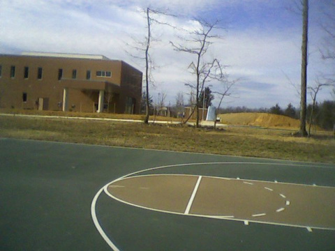
This park is located on Ridgefield Village Drive off of Hoadly Road. It's a five acre park that is dedicated to the memory of Earl Cunard, who was a long time volunteer advocate for quality development in Prince William County as a member of the Lake Ridge Occoquan Coles Civic Association.
A credit union building was recently constructed on a neighboring property. This development resulted in a major change in the nature of the entrance to the park since the land was cleared and graded right up to the park property line. The credit union building is starkly visible since only the entry road separates the park from the drive-up window (see picture below).
MIDCO has worked with LOCCA, the PWC Park Authority, the PWC Planning Office and the developer to mitigate this situation. The solution that was agreed to is to place a earthen berm between the park and the credit union building. The berm will be four feet tall with plantings on it to further screen the view. In addition, the current park entrance sign will be moved to the other side of the entrance and improved. Update 5/8/12: Due to safety concerns raised by Supervisor Jenkins' office, the earthen berm was nixed. Donny Gray from Lake Ridge Nursery stepped up and donated plantings for the park that addressed some of the community issues.