Bacon Race Fire House and Central District Police Station
Update: MIDCO will host a community event to perform maintenance on the reforestation area on Saturday, September 14th at 9 am. We will meet in the parking lot in front of the police station to sign a waiver and divide up into teams that will go to various parts of the reforestation area. We will weed, trim bushes and small trees, remove debris, remove tree stakes, etc. It would be a good idea to wear enclosed shoes, long pants, gloves and a hat. If you have a pair of clippers, a shovel, a weeder, or pruning shears, feel free to bring them. The time frame is flexible- work as long as you want. We will all likely be done by noon.
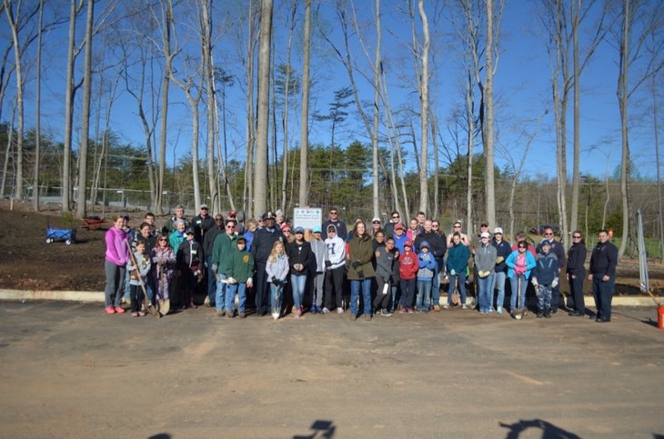
Report on the Initial Tree Planting Event at the Police/Fire Station Site
MIDCO initiated an effort to mitigate the over clearing of the new police/fire station shortly after we and other area residents noticed the situation in 2016. On Saturday, April 8, 2017 after many months of working with county staff (including project manager David Scott, County Arborist Julie Flanagan, Occoquan Supervisor Ruth Anderson and Chief of Staff Alex Stanley as well as Planning Commissioner Bill Milne) the MIDCO community, along with organized groups like girl scouts, boy scouts, youth ambassadors and other community members came together and planted over 500 seedlings on almost an acre at the new police and fire stations on Davis Ford Road.
Between county staff and volunteers, we had over 100 adults and children in attendance to help with the reforestation effort.
There are another 2 acres of reforestation that will be completed by the contractor by end of April/beginning of May (Virginia Water and Wetlands), and they will also be responsible for replacing any dead trees during the first year. The county has also contracted with them to water the new trees if needed.
|
8/23/16- The committee report on the reforestation of the police station site is here.
|
| ||
Update 9/4/14- The site plan for the police station is below. It shows the landscaping, setback from the road, etc. Click on the PDF symbol to download. The site plan is divided into two separate parts for the area along Davis Ford Road, so you need to download both halves.
| sht-059_signed.pdf |
| sht-058_signed.pdf |
This link will take you to the August 2014 county presentation showing the building design, among other things (you will need to copy it and paste it into your browser): http://media.wix.com/ugd/9f8499_d9b6bf2ee5cc4b6990dabe10e5259287.pdf
Older information:
Below are some proposed options for the new infrastructure. The intersection shown is Davis Ford Road and Prince William Parkway. Alternate locations for the buildings in the second slide would be in the "reserved for future development" areas. The yellow outline area in the first slide is a little off, it should be slid a little to the right to align with Davis Ford Road. The red arrows are possible access points to the property. The "right in/right out" shown in the first slide apparently could actually align with the current median break in the parkway and possibly provide emergency eastbound access to the Parkway.
The yellow half-circles with the plus sign in the second slide are the proposed limits of intrusion on the stream protection areas. In other words, the area in the dotted lines marked "future development" and the stream area outside the yellow half-circles are other areas that the police/fire buildings and parking lots could go. There has been encouragement from area residents that the county look into placing the buildings closer to the Parkway and leave more of a buffer between the new facility and existing residential development and from Davis Ford Road.
There have been two public meetings on this subject, and there will be one more in early 2014 (date TBA). As always, MIDCO is encouraging the community to comment on the project and give us and/or the county government your suggestions as to alternate layout, buffering for the buildings, preferred access, etc. Just place your cursor on "more" above and then go to the blog page. To provide your comments to the county, go to: [email protected]