Bacon Race Church
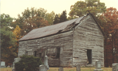
This church (shown above), which stood at the intersection of Bacon Race and Davis Ford Roads, was in operation from the 1880's to the 1930's, and finally fell down on Christmas Eve of 1984. The last preacher (Reverend William Smoot) of the church supposedly told his flock on his deathbed that he didn’t want anyone else preaching in his church until he came back, so they complied with his wishes and the church was never used again.
This church, also known as the Occoquan Baptist Church and the Oak Grove Church, was at the forefront of religious freedom in early America. Colonial-era Baptists took advantage of sentiments in favor of political freedom and petitioned the government for complete separation of church and state and freedom to worship as they pleased. The Occoquan Baptist Church was a leader in this effort and sent their petition to the Committee of Religion, Convention of Virginia, on May 11, 1776. The petition had three main conditions: to be able to worship as one pleases without interruption; to have one’s own ministers and no other; and that one may be married, buried, etc., without paying the Parsons of any other denominations.
The passing in Virginia of Thomas Jefferson’s “Establishing Religious Freedom” bill of 1785, placing Virginia in the forefront of religious freedom, was in part a result of the lobbying of the Occoquan Baptist church.
The church cemetery is still being used and is kept well maintained by the cemetery trustees and others. More information is available on the "cemetery" sub-tab in this section.
Old Davis Ford
One part of our area that is very interesting historically is the original Davis' Ford. According to a county historical map, this ford was roughly where Occoquan Club Drive ends now, and picked up on the other side of the river at the site of the boat launch ramp at Fountainhead Park. There is a large Davis family cemetery near the main parking lot in Fountainhead Park and the Davis family owned a lot of land on both sides of the Occoquan River. Davis Ford existed as a river crossing until the river was dammed at the current location downstream near the town of Occoquan in the 1950's. The old Davis Ford road that leads away from the ford follows the ridgeline roughly paralleling Occoquan Club Drive, and the old roadbed, four feet below grade in areas, can still be seen. According to Eugene Scheel's historic map, this road was Davis Ford Road and the road that is now Davis Ford Road running between Prince William Parkway and Yates Ford Road was at that time Bacon Race Road, possibly named after the stream paralleling it that is now known as Crooked Creek. There’s a Civil War gun emplacement along old Davis Ford Road overlooking the Occoquan River and Davis Ford, and there was a bivouac area nearby that has now been obliterated by road construction. There is also a Civil War breastworks (low chest-high earthen berm) near the river crossing, along with an 1890's era cemetery with around fifty graves. There’s evidence that this old road and river crossing has been around since colonial times, and may have been used by General George Washington’s troops as an alternate supply route in addition to it's role in the Civil War. According to period maps, the nearby crossing at Wolf Run Shoals was the primary river crossing for the Rochambeau Route (see below).
The Red House
If you’ve ever noticed the red house on Bacon Race Road across the street from Occoquan Club Drive (pictured at the top of the page), you’ve probably thought that it looks pretty old. From property record research, we’ve found that it dates back to around 1890. It’s not a log cabin, but in the basement you can see the floor is supported by logs with the bark still attached. The floorboards are held in place with hand-cut nails and the house has a beautiful part stone, part brick fireplace. More info under the "Red House Pictures" tab.
Simpson Property
Another property near us that dates back hundreds of years is in the Cannon Bluff neighborhood near the end of Bacon Race Road. There are remains of a house and out buildings at Wolf Run Shoals that were part of a farm and gristmill dating back to the 1700’s. George Simpson built the gristmill around 1770, and the Simpson family owned the property into the early 1900’s. Dorcas Simpson, the last person buried in the cemetery on the property was the grandmother of Clinton Purcell, who owned the farm at the intersection of Bacon Race and Davis Ford Roads.
Hoadly
Yes, there was a town of Hoadly, complete with a Post Office. You can still see some of the homes, which were along both sides of Prince William Parkway in the McCoart area and along Hoadly Road and Davis Ford Road. The original Sacred Heart Catholic Church near the intersection of Hoadly and Purcell Road was also considered to be part of Hoadly, as was Bacon Race Church.
Rochambeau Route
This old road, which ran along the east coast mostly along the route of an old Indian path, was an important trade and supply route from the time of the earliest settlers. It was used to supply Continental Army troops at Yorktown and Civil War troops in the 1860’s. It runs right through our mid-county area, crossing the Occoquan River in the Bacon Race Road vicinity and moving south, crossing today’s Davis Ford Road, Prince William Parkway, and Rt. 234 on it’s way through the county
Ryons Dam
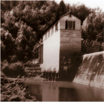
Part of this dam (shown above) can still be seen in the Occoquan Reservoir about half a mile upstream of Fountainhead Marina. It provided power hydroelectrically to the surrounding area, helping with rural electrification. The building on top of the dam is no longer there, and the main dam structure is now underwater. Ryons Dam was instrumental in providing much-needed employment for area residents in the late 1920's. There was a house and other related buildings on shore immediately next to the dam.
The dam was built by Fred B. Ryons, a Colonel in WW I and a military engineer with an interest in hydroelectric energy. The residents in the area were not very wealthy, and work was hard to find. Most of the economy was agricultural, and probably the most common industry after farming was the production of "moonshine," which was mostly sold in Washington, D.C.
Colonel Ryons found willing sellers of the land that would be flooded by his project. Most of the homes were on the higher areas of the parcels, and he let the owners stay for life in the homes. His dam building resulted in employment for many residents in the area such as Henry Purcell, who had a sawmill and benefited from the project. Henry's oldest son, Clinton, remembered much of the detail of the building of the dam. Clinton owned the farm at the corner of Davis Ford and Bacon Race Roads until he passed away recently. Clinton and Rue Purcell's grandmother, Dorcas Simpson, lived near the dam and she and her brother Robert sold the Simpson farm to Colonel Ryons on December 28, 1927. Clinton spent a good deal of time with the Simpson's, and visited the dam often during construction. One of his most vivid memories of the project was of the swinging bridge spanning the Occoquan that the workers used to cross.
Colonel Ryons built a fine house for himself and his wife on top of the hill overlooking the Dam. He also built cottages on the property for his stepdaughters. Until approximately 2004 the cottages were still standing and the foundation was still intact for the mansion.
The property was sold to the Alexandra Water Company on 12/17/1947. On 4/6/1971 the land was sold to the Occoquan Land Company. It was later sold to Diane Cox Basheer, who in turn sold it to Mike Garcia. The Ryons estate structures were demolished and a new house built, which is now part of a ten acre private residence.
Buckhall
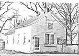
Buckhall has been a town since before the Civil War. The Buckhall School dates to around 1865, and the Thomasson House from 1825. The Kemper House was built around 1850, and of course the Buckhall Store has been there for many, many years. Below is a picture of Buckhall School.
The Geisler Property
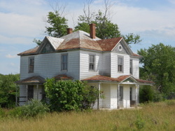
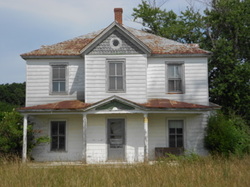
The house on the left and below is near the corner of Route 234 and Hoadly Road. It was built in the early part of the 20th century and was home for the family that owned the farm at that location. It is reportedly a Sears catalog home, delivered by rail car and assembled on site. It has many fine details, including fish scale shingles, a stamped tin roof, bay window boxes on both sides, and two central chimneys.
Civilian Conservation Corps (CCC)
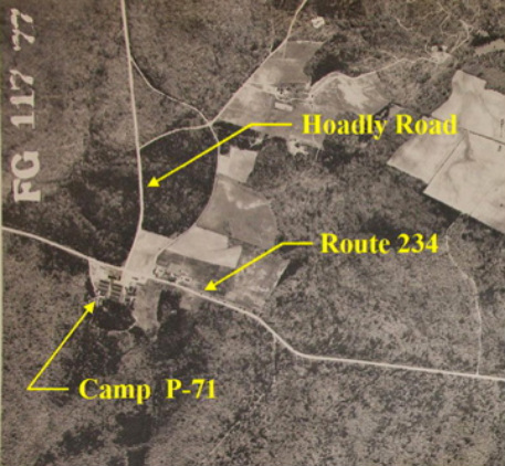
The CCC was formed during the 1930's to provide employment for those without a job on public works projects. There was a lot of CCC activity in Prince William, including in what is now Prince William Forest Park, where the CCC built roads, cabins, etc. The first CCC camp in Prince William was at Rt. 234 and Hoadly Road (on left- Camp P-71). For more info use the link below. http://www.pwcgov.org/government/dept/library/Documents/RELIC/Reliquary/PWR_1-2008.pdf
