How We Grew and Grew- Highways and Cheap Housing Made It Happen
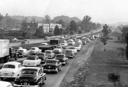
Virginia's first limited access freeway, the Henry G. Shirley Memorial Highway, was completed in 1952. It was 17.3 miles long and stretched from Woodbridge to the 14th Street Bridge over the Potomac River. Upgrades and expansions have continued since about the mid-1960s, as Washington, D.C.’s outer suburbs grew.
In 1600, around the time of the arrival of the first Europeans, it is estimated that between 14,000 and 25,000 American Indians lived in eastern Virginia. It’s not clear how many actually lived in the area that’s now Prince William County, but it was surely fewer than 10,000. The Doeg Indians hunted, fished, grew corn and other crops and lived in villages, and their local one was located just off of U.S. 1 near the now closed Lazy Susan dinner theater.
Early European settlers gained a lot from their relationship with the Doegs, from adopting their agricultural practices and place names (Quantico, Marumsco, Occoquan) to using their roads to even inhabiting their villages once they were gone. Europeans also learned Indian battle techniques, using them to great advantage against the British during the Revolutionary War.
The other tribe in the Prince William area was the Manahoacs, who were nomadic hunters and didn’t stay in one location for long. As more settlers came to the county, the Indians died of European diseases or moved from Prince William further west or south, mostly to get out of the way of the settlers.
Consequently, by the late 1700s after the native peoples were mostly gone from Prince William, a population of about 10,000 people remained. These were mostly immigrants from Europe and enslaved people from Africa.
From this point, believe it or not, the overall population of Prince William didn’t really change much for the next 140 years. Between 1790 and 1930 there were ups and downs to be sure, but the total population remained fairly close to 10,000. There was a downward trend at the turn of the 16th century due to westward migration. The soils in the east were depleted and harbors silted in due to farming practices, so settlers were looking for better farming and mining opportunities, among other things. In 1790, the Prince William population was 11,615, and in 1800 it was 12,733. After this it steadily dropped until 1850 when it was down to 8,129.
Parsing the numbers
When looking at early population numbers, we need to keep a few things in mind. Only free heads of households were counted in the census until 1840, with others, including slaves, being noted statistically under heads of household. The 1870 census was the first to include African Americans by name. Native Americans weren’t counted throughout the country until 1890. All this plus subjectivity on the part of the counter makes one wonder how accurate the counts really were.
Population low point
In any case, by 1870, after the Civil War, the county population had further declined to 7,504. After the war, the southern economy was decimated, the way of life changed and many folks left, including some former slaves. It’s also important to note that more than a few came in to help rebuild and also take advantage of cheap land. But overall, the population dropped. Think about this: the population of the entire county in 1870 was about the same as that of Dumfries today.
After that came a long, rollercoaster-like increase in county population that continues to the current day. There were huge increases in some decades and less in others, but the trend was always upward. The number of people living in Prince William County grew to 9,180 by 1880; 9,805 by 1890; 11,112 by 1900; 12,026 by 1910; 13,660 by 1920, and to 13,951 by 1930. As noted earlier, our population didn’t change much between 1790 to 1930, but after 1930 things really began to happen. According to the 1940 and 1950 census, the population grew by about 27% each decade.
A new cash crop: Housing
But the huge increase in folks coming to Prince William started to show in the 1960 census. From 1950 to 1960, the population more than doubled, and from 1960 to 1970 it more than doubled once again, increasing by over 121% each decade. A major factor in this growth was the extension of Shirley Highway to Woodbridge in 1952.
Shirley Highway – a precursor to Interstate 95 --was the first limited-access highway in Virginia, and it suddenly made Woodbridge and Prince William County very attractive as a bedroom community for folks who worked in Washington, D.C. and other northern locations. After World War II, the requirements for dairy production changed, and many dairy farms in Prince William couldn’t keep up with the new standards, but they could grow homes on the land as a cash crop.
The post-war building boom was on, and Prince William provided cheap land and affordable housing with yards that kids could play in. Employers like IBM came to Manassas in the ’60s and ’70s, and Interstate 66 opened in 1964, which were among the drivers for population growth in western Prince William.
After those huge increases, growth slowed somewhat in the 1970s and 1980s, but still increased by 30% from 1970 to 1980 and 49% from 1980 to 1990. The housing needs of the returning WWII veterans had peaked, and the baby boomers were just starting to buy homes in large numbers. Growth from 1990 to 2000 was 30%, and again 30% from 2000 to 2010. It was 17% from 2010 to 2020.
You can see that there really wasn’t a huge population change from 1600, when there were somewhere under 10,000 people here, to 330 years later when there were about 14,000 people here. But for the next 90 years, the county population grew incredibly – from 13,951 in 1930 to 474,435 in 2020, or 34 times as many folks. For context, in the same period the population of the northeast increased 1.67 times, and the entire country’s 2.7 times.
The reason for the explosive growth in Prince William wasn’t mining, it wasn’t farming, and it wasn’t logging, although all those things brought folks here in the early days of the county. The things that brought the most folks here, and continues to, is less expensive housing due to being further away from the employment available to our north and east. The most profitable thing to grow on Prince William land turned out to be low-cost housing.
The federal government and associated employers brought a huge increase in employment to the D.C. area during WWII and thereafter, and a vastly expanded regional highway network made Prince William County viable as a bedroom community. Prince William was, and is, far enough out that the land, and therefore the housing, is more affordable than it is in the closer-in suburbs, but most folks have to travel outside the county to get to work.
So, given past trends, will the population of Prince William 90 years from now be 34 times higher than today, with more than 16 million folks? How will we deal with the environmental and mobility impacts? Will something happen again that actually leads to a reduction in population? Or will the answer be something in between?
Only time will tell.